Google’s augmented reality Maps are live for some users
By Sara Shaw • February 15, 2019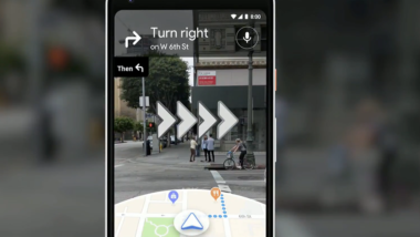
In May 2018, during its annual I/O developer conference, Google announced a new feature for its Maps mobile app, called the AR Visual Positioning System. It provides navigation via a layer of augmented reality, plastered over actual reality as seen through your phone’s camera. To use it, you lift the phone in front of your eyes and the software gives you directions via arrows which show where you need to go.
Google’s user-experience lead for the AR project, Rachel Inman, told the WSJ the feature is not meant to be your primary navigation tool. She said it’s most useful at complicated intersections or finding a hidden alley.
According to the Wall Street Journal, Google is making the feature available to a small subset of users and will not be widely available and until Google is “satisfied that it’s ready.”